So you finally upgraded to a fish finder with GPS capability only to discover how lacking the built in maps are for areas north of the border into Canada. Sure, you could shell out $$ for a premium map package, but those don’t give you much more than a lake outline for most bodies of water in canoe country. Wouldn’t it be nice to use your fish finder’s GPS to it’s full potential while fishing and perhaps even as a secondary navigation aid to find campsites, portages, pictographs and more? Maybe even record your sonar data and turn them into detailed lake depth maps for future trip reference? Now you can, and the best part is it is 100% free! For Lowrance users only. …Read on to find out more.
The above download contains a Lowrance format, AT-5 Map, that is compatible with most Lowrance Fish Finder Combo units manufactured in the last 12+ years. (HDS, Elite Ti2, Elite FS, Elite HDI, Elite Chirp, Elite Ti, Hook, Hook 2, Hook Reveal, or the latest Eagle units(2024+). You must have a unit with an SD card slot, “X” units will not work as they are non-mapping units. Smaller screens consume less power, so a 4 or 5 inch unit is ideal for canoe use. The Eagle 5 split shot, will provide the best user experience, though older units work just fine, with a slight lag when zooming in and out on the map. Dial down your screen brightness 3 notches and you will find your power draw will decrease, allowing significantly longer run times.
Installing the Map:
Simply unzip and copy the folders to the root of your SD card that has been formatted as FAT32(important). I recommend an SD card rated as either V30 or A2 for best performance in either 32GB or 64GB in size. Please see the detailed instructions in the included readme file for more information.
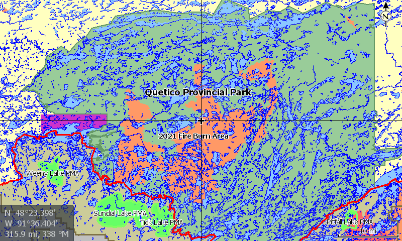
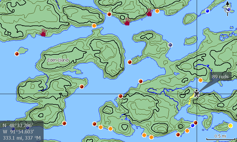
This Free vector based map consists of the following features for Quetico and the BWCAW:
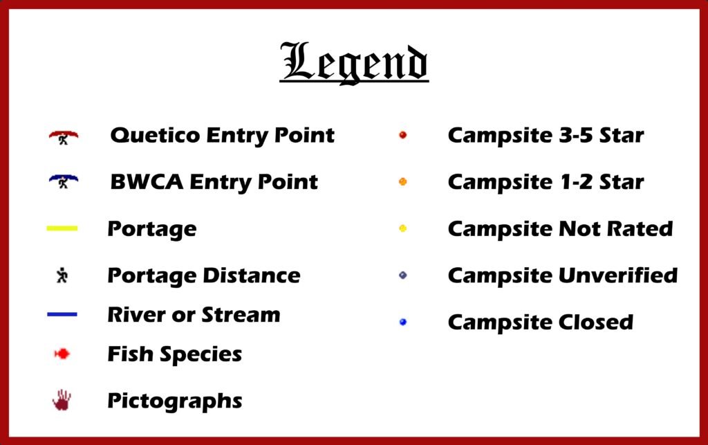
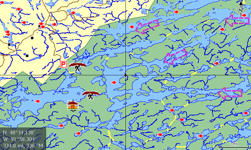
- Accurate Lake boundaries with islands, rivers, streams and emergent rocks shown.
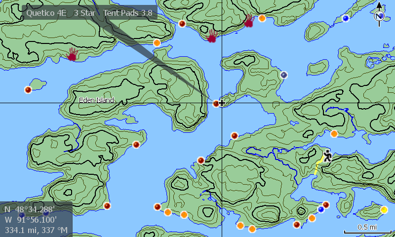
- Detailed Campsite and Portage information. 2
- Campsite ratings and tent pads displayed where available.
- Portages in Rods.
- Select Anishinaabe pictograph locations revealed.3
- Land contours for evaluating elevation changes. ( 10M= Quetico, 30 Ft =BWCAW).
- Recent burn areas are displayed for reference or avoidance.
- Entry Points for both areas, as well as permit stations and outfitter locations.
- Fish Species data for most lakes. Also, Secchi water clarity data for select Quetico waters.
- Park and International boundary clearly displayed.
- Selected areas of water flow direction in Quetico.
- BWCAW Primative Management Area coverage for the bushwhackers out there.
- Roads and trails displayed for reference purposes.
- First Nation Reserve shown – Gakijiwanong Anishinaabe Nation (Lac La Croix)
- Lake and area names displayed for quick reference and orientation.
- Wide area reference points/features for quick orientation and navigation to specific areas of focus.
- All Data is embedded into map layers, No waypoints are used. Save your limited waypoints for marking your fish, discoveries or observations.
- Feature details Appear/Disappear based on zoom level to prevent screen clutter and present data only when needed.
- Custom Advantage Gear LLC is not affiliated with Lowrance or CMAP Genesis.
- Source: PaddlePlanner.com (Used with permission.)
- Source: Peter Albinger’s Ramblin’ Boy website. (Used with permission.)
- Contains information licensed under the Open Government License – Ontario, Ontario Ministry of Natural Resources and the Queen’s Printer.
- Contains data compiled from contributions made by the MNDNR, U.S. Geological Survey, MDNR Division of Fish & Wildlife – Fisheries Unit, National Interagency Fire Center & National Oceanic and Atmospheric Administration.
- No Warranty is expressed or implied. The Free software included in this product is distributed in the hope that it will be useful, but WITHOUT ANY LIABILITY OF OR ANY WARRANTY from Custom Advantage Gear, LLC or from the government agencies, individuals or organizations which provided the underlying source data. Do not rely on this product as your primary source of navigation. Data may be incorrect or missing, or water levels or conditions may have changed, as often happens in areas inhabited by beavers. Always be aware of your surroundings and use good judgment. Water levels are often different between lakes, and moving water can be dangerous. Locate and use the portages whenever possible. User assumes all liability for operation and associated risks.
.

There are two version of this map data included in the download. One is a stand alone map that will show up on your unit as “Q BW FE MAP” The other map contains the same data, but is named the same as a CMAP Social Map and will show up as ” C-Map Social Map” on your unit.
Main Map Atlas Description = “D=Q BW FE Map”
Social Map(Insight Geneisis) Version Atlas Description = “D=Social Map|M=C-MAP”
This information is helpful if you wish to create your own data overlay for this map using the Insight Map Creator Application from Navico/Lowrance, or if you simply want use the map as a base for a social map downloaded from CMAP Genesis. Map files with the same Description ID/Name will be shown on the device simultaneously.


The Social Map version in this map pack will allow you to load maps from the CMAP Genesis social map website as an overlay to the data provided. Simply place both the downloaded map from CMAP and the Social version of this map on your SD card. Since they have the same Atlas Description, or Map Name, they will be shown simultaneously. The data you download from CMAP has preference and will be shown on top of this Fishing Enthusiast map, so some features such as shoreline details may be slightly inaccurate or blocked out in certain areas (Due to interpolation and they way CMAP clips the contour limits to their own maps, which are not as accurate when it comes to shoreline locations.) However, you can have both versions of the map on your SD card, so you can switch between them for comparison purposes.
Contribute your own data by logging your sonar data to your SD card and later uploading the files to the social map website at https://www.c-map.com/social-map/. It’s free and everyone benefits! These lakes are too big and remote to map all at once while paddling a canoe, but together we can fill in the data and make a difference piece by piece.
There is so much structure present, in remote locations no less, that one need not worry about revealing secret honey holes and keeping data private as one might feel the need to do in rural high pressure fishing areas. There are no “Fish Here” signs or waypoints shared on the map, so you are not really giving up your favorite honey holes, the map depends on individual interpretation and fish move throughout the year, so hot spots do change and results vary. The permit system alone ensures there won’t be a ton of fishing pressure anywhere at one time in Quetico. Bathymetry depth maps help to save our precious time while fishing in canoe country and try to help us focus our efforts on structure elements we think might hold fish. It is the old addage that 90% of the fish inhabit 10% of the water.


Turtle River/White Otter and Beyond – Bonus Map
This is a Bonus map that covers the area in and around the Turtle River White Otter Provincial Park, just to the North of Quetico. The map can be combined with our Quetico and Boundary Waters Fishing Enthusiast Map or can be installed on separately by simply copying the unzipped folders over to the root of your SD Card. This map information is useful both to paddlers and those who use a motorboat while fishing area lakes where coverage extends, benefiting local lodge and fly in cabin guests as well.
The Campsite and Portage information contained in this map should be used with caution as I did my best to manually place them, but their accuracy is not guaranteed. They should be used as a general reference only as to their locations.


